University of Minnesota experts reveal top 100 rural traffic safety "Hot Zones"
Online map identifies rural areas with most driving fatalities in time for July 4th travel ~ SafeRoadMaps Version 2 is launched.
MINNEAPOLIS / ST. PAUL (06/30/2009) -- Rural transportation safety experts at the University of Minnesota today launched a new national service to help drivers identify the most dangerous portions of upcoming trips, including trips that will be made this Independence Day, which is often the most dangerous travel day of the year.
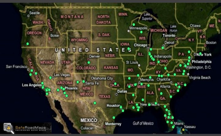
SafeRoadMaps.org is a service that immediately identifies the location of crashes through an online, searchable map. The service was launched last summer by the University of Minnesota's Center for Excellence in Rural Safety (CERS), but starting today it will flag the nation's Top 100 "Hot Zones," the rural areas that have experienced the most fatalities over the past five years. The hot zones are presented in a visually arresting Google Map-based format, where viewers can zoom from a national map showing all 100 zones, down to a photo of each individual section of the road.
The newest version of SafeRoadMaps.org offers several other enhancements over the original version released in 2008. SafeRoadMaps now allows anyone visiting www.saferoadmaps.org to enter a zip code, municipality name or street address and immediately see a map or satellite image all of the road fatalities that have occurred in the chosen area over the past five years. Details about each crash are also available, such as whether the driver was wearing a seatbelt, drinking or speeding. The tool also notes which life-saving public policies, such as strong seat belt laws, are being employed in the chosen area.
CERS was created in 2005 through the leadership of Minnesota Congressman Jim Oberstar, chairman of the U.S. House Committee on Transportation and Infrastructure. Oberstar has encouraged CERS to make rural safety more visual, localized and personal to the nation's drivers and leaders.
While U.S. Census figures show that about one out of five (21 percent) Americans live in rural areas, the Federal Highway Administration (FHWA) has found that about six out of 10 (57 percent) highway deaths occur on roads that it considers rural.
"Whether you're a driver, policymaker or a road engineer, this is an eye opener," said Oberstar. "Crash data used to be stored in huge dusty stacks of paper in Washington, D.C. We've made sure the information is instantly available on millions of screens, and it is available in a dramatically visual and customized format. This is as important to better highway safety as the interstate map was to achieving national mobility."
The Safety Advisory Zones include 100 from rural areas. While 29 states have rural areas in the Top 100, the ten states with the most "hot zones" are Arizona, Arkansas, California, Florida, Indiana, Louisiana, Maryland, North Carolina, Texas and Virginia (in alphabetical order). A searchable map showing all of the hot zones is available at www.saferoadmaps.org.
"Drivers often think of rural safety as an issue only for the least populous states," said Tom Horan, CERS Research Director. "But this analysis shows that drivers need to be extra alert in rural regions of the more populous states as well."
The SafeRoadMaps.org tool is being used in a variety of ways to educate the public about road fatalities. For instance, driver's education leaders have advocated use of the tool as a means to teach new drivers the importance of following the rules of the road. Drivers are exploring their most common routes and being educated about the need to take sensible precautions. Finally, road safety officials are using the tool to better pinpoint where policy, structural and traffic management adjustments are most needed.
"SafeRoadMaps is not about casting blame," said Lee Munnich, CERS Director. "This is about making sure drivers are informed and safe, and policymakers have a user friendly tool to guide their safety related decisions."
In addition to rural hot zones, SafeRoadMaps now also identifies urban hot zones. Eighteen states have urban areas in the Top 100. The 10 states with the most "hot zones" are Arizona, California, Florida, Hawaii, Maryland, Nevada, New Jersey, New York, Pennsylvania and Texas. These urban zones are also viewable on www.saferoadmaps.org.
The Center for Excellence in Rural Safety provides citizen-centered research, training, and outreach to enhance rural safety and to meet the needs of rural transportation practitioners and policymakers. It operates as a joint venture of the University of Minnesota's Humphrey Institute of Public Affairs and Center for Transportation Studies.
A weblog produced by the State and Local Policy Program and the Regional Planning and Policy area at the University of Minnesota's Hubert H. Humphrey Institute of Public Afairs
Newsfeed

Categories
- About Our Blog
- Mileage-based User Fees
- Regional Planning and Policy
- State and Local Policy Program
- Bicycling Facilities Research
- Congestion pricing
- Economic development
- Economic Competitiveness
- Industry Cluster Studies
- Rural Knowledge Clusters
- Mileage-based User Fees
- Rural Safety
- Telecommunications and Information Society
- Telework - Telecommuting
- Transportation and Planning Technologies
- Topics